| About coordinate systems
To locate a point in (3-dimensional) space, three coordinates are needed.
The Cartesian coordinate system uses the x,y and z-coordinates,
which give the distance from a point to the three coordinate axes.
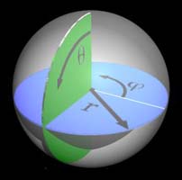
Another useful coordinate system is the Spherical Coordinate System.
Here the position of a point is determined bij its distance r to the origin and by two angles.
See the picture to the right.
The polar angle θ measures the angle with the positive z-axis,
and the azimuthal angle φ measures the angle with the positive x-axis,
in the x-y plane .
From the picture it is clear that θ can have values between 0º and 180º,
while φ will have values between 0º and 360º
|
|
The Spherical Coordinate System is very suitable to locate positions on the surface of the earth,
because the earth is approximately a sphere, so r is constant (about 6367 km)
As a consequence the two angle coordinates are sufficient to locate any point on the surface of the earth!
|
|
Of course a choice has to be made about the x, y and z-axis.
The logical choice for the z-axis is the rotation axis of the earth, the line between North and South Pole.
This defines the equatorial plane as the x-y plane.
But how to choose the x-axis?
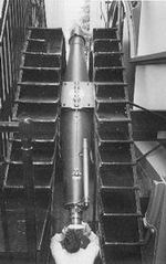
In 1884 on the International Meridian Conference in Washington it was decided to fix the x-axis
so that the Royal Observatory in Greenwich would be exactly in the x-z plane.
So φ = 0 for the Royal Observatory.
The half circle from North to South Pole passing through (one specific telescope in) the Royal Observatory
was called the Prime Meridian.
This telescope, built by the Royal Astronomer Sir George Airy in 1851 can be seen in the picture to the left
|
|
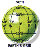
When we draw the equator in 360 equal parts, we can draw 360 half circles, which are called Meridians
and which together form one half of a grid.
The other half is formed by dividing the Prime Meridian in 180 equal parts,
and drawing 180 full circles parallel to the equatorial plane.
Those circles are called Parallels.
The counting of the Meridians and Parallels is done in degrees
but in a slightly different way from the Spherical Coordinate System.
For the Parallels the starting point is the equator and the Parallels count until 90º in the North and 90º in the South.
The Meridians are counted from the Prime Meridian: 180º to the East and 180º to the West.
|
|

|
The polar angle is given as the latitude and the azimuthal angle as the longitude.
When the angles are not integer degrees, they are subdivided in minutes (1/60 degree)
Example:
The position of the Petronas Towers in Kuala Lumpur is given by a latitude of 3º 9.5' N
and a longitude of 101º 42.8' E .
Is there anything special about the place on earth with latitude and longitude both equal to 0º ?
This origin of the global grid system is located about 600 km south of Ghana in the middle of the Atlantic Ocean!
|
Degree Confluences
|
A degree confluence is the exact spot where an integer degree of latitude and an integer degree of longitude meet.
Those spots are not marked in any way on the surface of the earth and generally there will be nothing special to see.
But in recent years, with the increasing popularity of GPS devices, a new sport/hobby has developed:
to visit the degree confluences of the earth and publish a report about it on the Internet.
The originator of this undertaking has been Alex Jarrett and the results can be found on the Degree Confluence website.
How many of these confluences exist?
There are 179 Parallells between South and North Pole. Each Parallel has 360 degree confluences. The poles themselves are confluences,
so the total number of confluences is (179x369) + 2 = 64442.
How far apart are confluence points?
For points with the same longitude, the answer is simple: 1 degree latitude corresponds with 111 km.
This is because each Meridian has a length of half the circumference of the Earth.
For points with the same latitude, the answer is less straightforward, because the parallels do NOT have the same length,
they become shorter nearer the Poles.
Near the equator, 1 degree longitude corresponds with 111 km, but near the North Pole, for example at a latitude of 89º N,
the length of the parallel is only 698 km (40000xcos(89)), which gives a distance of less than 2 km for 1 degree longitude!.
|
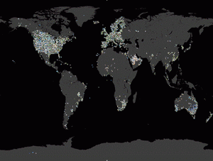
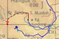
Because the oceans form a large part of the earth, many confluence points are located on the sea.
When we restrict ourselves to confluence points which are on solid ground or from where at least land can be seen,
the total number of "valid" confluence points amounts to about 24000.
Of these points a total of about 2400 has been visited until now (March 2003).
The visited degree confluences are shown in the picture on the right as colored dots.
A beautiful large scale and clickable map can be found on the
Confluence site.
|
|
My Own Contribution

|
|
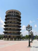
On 17-3-2003 we have visited the 4°N 101°E degree confluence.
This point is located in a palm oil plantation (left picture) not so far from Teluk Intan with its famous Leaning Tower. (Picture to the right).
The full report can be found here.
|
| |

|
|
On 23-3-2003 I joined a friend for an attempt at the 3°N 102°E degree confluence.
He had tried it a few times already, but this confluence is in the middle of thick, inpenetrable jungle!
This time we came until within 1.7 km from the confluence, before we had to give up. However, the visit has been accepted as an attempt
and can be found here.
Maybe we can try another time, using a different approach.....
|
|
|
|